GeoLens
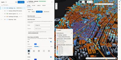
Transforming scattered spatial files into an interactive data catalog, GeoLens empowers engineering and GIS teams to organize geospatial assets, execute semantic searches, and build interactive 3D maps on self-hosted infrastructure. Users can ingest shapefiles, GeoJSON boundaries, database tables, and Cloud-Optimized GeoTIFF rasters into a centralized inventory with automatic source freshness auditing. Natural language queries evaluate dataset relevance across spatial boundaries and thematic tags, allowing analysts to uncover hydrology networks or zoning footprints without knowing exact layer names. The browser-based composition canvas lets cartographers extrude three-dimensional building footprints, overlay elevation terrain contours, color features by attribute values, and reorder layer hierarchies with drag-and-drop ease. Finished map projects publish immediately as secure shareable web links or responsive embeds for external dashboards. Desktop GIS operators can connect directly from QGIS or ArcGIS through native OGC API Features and STAC endpoints to query live vector tiles and run spatial filters. Teams can export filtered geometries into GeoPackage, FlatGeobuf, GeoParquet, or PMTiles archives to support downstream analysis workflows. Running on a dedicated VPS on RepoCloud with guaranteed CPU, RAM, and SSD, full root SSH access, and a browser serial console. Apache 2.0 licensed.
OpenRouteService
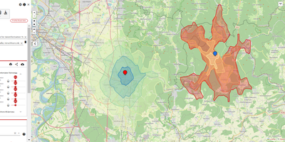
OpenRouteService gives applications driving directions, reachable-area polygons, and origin-destination travel times computed from OpenStreetMap data on hardware you control, with no metered API key. Ask for a route and it answers with turn-by-turn instructions, distance, duration, and elevation gain for cars, heavy trucks, several cycling styles, walking, hiking, and wheelchairs. Draw an isochrone and the map fills with the area reachable inside five, fifteen, or sixty minutes, ready for site selection, delivery zones, and coverage studies. The matrix endpoint prices every pairing in a grid of origins and destinations in one request, so fleet tools and location analytics stop making thousands of single calls. Steer results with avoid areas, controlled borders, tollways, ferries, and road classes, with per-request limits on distance and climb. Snap stray GPS points back onto the road network, export the underlying graph for your own network analysis, and watch instance health from the built-in status endpoints. Load the regional OpenStreetMap extract you actually serve, rebuild graphs on your schedule, and every answer stays inside your network at whatever volume your hardware allows. Running on a dedicated VPS on RepoCloud with guaranteed CPU, RAM, and SSD, full root SSH access, and a browser serial console. GPL-3.0 licensed.
OSRM
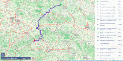
OSRM computes the fastest route between any two points, the travel time between every pair of stops, and the road a noisy GPS trace really followed, all from OpenStreetMap data on your own server. Feed it a map extract for your city or the whole planet, preprocess it with the car, bicycle, or foot profile, and the HTTP API starts answering. The route service returns turn-ready paths with distances, durations, and geometry between any coordinates. The table service computes the full duration or distance matrix between all pairs of points, which is the raw material for dispatching, territory planning, and pickup optimization. Map matching snaps noisy GPS traces onto the road network in the most plausible way, cleaning fleet and fitness data into actual driven streets. The trip service orders a set of stops into an efficient round trip, and the nearest service snaps raw coordinates to the closest road segments. A tile service exposes routing metadata as vector tiles for debugging and visualization, and a public demo frontend shows routes on a live map. Running on a dedicated VPS on RepoCloud with guaranteed CPU, RAM, and SSD, full root SSH access, and a browser serial console. BSD-2-Clause licensed.
TileServer GL
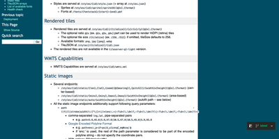
TileServer GL turns map data files on your server into the styled map tiles that websites and mobile apps expect, so your maps stop depending on a commercial tile provider and its usage bill. Feed it an MBTiles or PMTiles file, for example an OpenMapTiles extract of a city, a country, or the whole planet, and it serves vector tiles straight from the file to MapLibre GL JS, mobile SDKs, Leaflet, and OpenLayers clients. The full version renders raster tiles on the server side too, producing PNG, JPEG, and WebP images at standard or retina resolutions for clients that cannot draw vector maps. Cartography stays in your hands through GL styles: the server hosts the style JSON, sprites, and font glyphs, and every layer color, label, and road casing can be restyled and republished without touching the underlying data. GIS tools connect through WMTS capabilities documents, and TileJSON endpoints describe every served dataset for automatic client configuration. Static image endpoints answer with finished map pictures for reports, thumbnails, and emails, centered on coordinates or fitted to an area, with route lines and markers drawn onto the image on request. A built-in browser viewer lists your styles and data sources for a quick look at what is being served, terrain datasets can answer elevation queries by coordinate, and a health endpoint reports when the server is ready. Running on a dedicated VPS on RepoCloud with guaranteed CPU, RAM, and SSD, full root SSH access, and a browser serial console. BSD-2-Clause licensed.
Dawarich Atlas
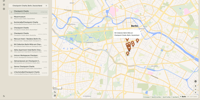
Atlas turns OpenStreetMap data for a city, a country, or the whole planet into a maps backend your applications can search, route with, and query for nearby places, all on hardware you control: pick a region and it downloads and indexes that territory's data locally. Search behaves the way users expect, with autocomplete matches grouped into clusters across the installed dataset, numbered so dense areas stay readable, and a show-all action that frames the full result set. Routing returns directions for driving, cycling, and walking, and a map-matching endpoint snaps noisy recorded GPS tracks onto the real road network. Ask what is here at any coordinate and category pickers surface restaurants, stations, parking, and hundreds of other place types around it, while transit planning threads timetables into door-to-door journeys. The settings panel is the control room: toggle search, routing, points of interest, and transit independently, switch the active region, and watch live progress as new territory is ingested and merged in the background. Developers plug in through one consistent JSON API covering geocoding, reverse geocoding in batches, coverage checks, and every map capability, documented as a public OpenAPI reference. Because every dataset lives on the box, the map keeps answering during outages and inside private networks. Running on a dedicated VPS on RepoCloud with guaranteed CPU, RAM, and SSD, full root SSH access, and a browser serial console. AGPL-3.0 licensed.
uMap
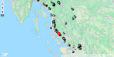
uMap turns OpenStreetMap into a personal mapmaking canvas: draw markers, lines and polygons in the browser, layer your own data over detailed street maps, and embed the finished map in any website. Each map is built from data layers you can style independently, choosing marker shapes, colors, icons and popups that show names, descriptions, photos or videos when clicked. You can sketch points of interest by hand or batch import whole datasets in GeoJSON, GPX, KML or OSM format, then let clustering group dense markers or a heatmap reveal where things concentrate. Backgrounds come from a choice of OpenStreetMap based tile layers, so the same map can sit on a street plan or a cycling map depending on the audience. Finished maps embed with a snippet of HTML, stay interactive inside the page, and can be downloaded or shared by link with read only access for viewers. Permissions decide who owns, edits or only views each map, and with real time collaboration switched on, several editors can draw on the same map simultaneously and watch each other's changes appear live. A slideshow mode turns layers into a guided story, stepping viewers through places in order with text and media attached to each stop. Running on a dedicated VPS on RepoCloud with guaranteed CPU, RAM, and SSD, full root SSH access, and a browser serial console. AGPL-3.0 licensed.