
Gods Eye View
God's Eye View turns your browser into a real-time spatial intelligence command center, rendering thousands of live aircraft, ships, satellites, earthquakes, traffic flows, and public cameras on a photorealistic 3D Earth powered by CesiumJS and Google Photorealistic 3D Tiles. Click any aircraft to see its transponder telemetry from OpenSky and adsb.lol, including route history, altitude, speed, and callsign; track live vessel positions worldwide through AIS beacon data from AISStream; or follow roughly 840 satellites color-coded by class using orbital elements from CelesTrak. A hands-free voice agent powered by the OpenAI Realtime API lets you ask the planet questions in natural language, and the globe annotates your answer directly in 3D space. Toggle FLIR mode for a thermal camera aesthetic, layer in NASA FIRMS wildfire data, switch between Google 3D, Bing aerial, and OpenStreetMap base layers, or tune into a geolocated world radio dial. Public CCTV cameras are projected into 3D city geometry with viewshed cones and direct-manipulation calibration. The cockpit mode provides a pilot-style briefing surface with mission-specific overlays. Entity inspection panels show detailed metadata for every tracked object, and shareable links let you send any scene configuration to a colleague. Ten of the thirteen live data layers work with zero API keys, while the required Google Maps key offers 1,000 free 3D tile sessions per month. Running on a dedicated VPS on RepoCloud with guaranteed CPU, RAM, and SSD, full root SSH access, and a browser serial console. MIT licensed.
portracker
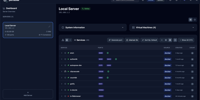
No spreadsheet has to track which service owns which port, because portracker discovers every service and port on your servers and keeps the list current from a self-hosted dashboard. Begin with a single port, shown with its owning service, its source (Docker or the host system), and its address, with internal container ports told apart from ports published to the host. Step back and ports gather into services: expandable cards carrying an icon, a health dot, and a port count, in list, grid, or table layouts, where a Why this status popover names the failing component and the rule that fired. Step back again and each server gets its own panel with hostname, OS, CPU, memory, and uptime, plus TrueNAS apps, VMs, and LXC containers once an API key is added. Step back once more and the whole fleet appears, because other portracker instances can be linked as peers, a VM's instance can be nested under its host, and every server can be searched at once. Along the way, rename services, hide the noisy ones, attach notes, act on a selection in bulk, or press Generate port for an unused number before deploying something new. Optional sign-in with a first-run setup wizard, an autoxpose link that shows public URLs and SSL status, light and dark themes, and keyboard shortcuts finish the picture. Running on a dedicated VPS on RepoCloud with guaranteed CPU, RAM, and SSD, full root SSH access, and a browser serial console. MIT licensed.
GeoLens
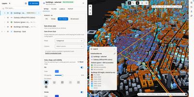
Transforming scattered spatial files into an interactive data catalog, GeoLens empowers engineering and GIS teams to organize geospatial assets, execute semantic searches, and build interactive 3D maps on self-hosted infrastructure. Users can ingest shapefiles, GeoJSON boundaries, database tables, and Cloud-Optimized GeoTIFF rasters into a centralized inventory with automatic source freshness auditing. Natural language queries evaluate dataset relevance across spatial boundaries and thematic tags, allowing analysts to uncover hydrology networks or zoning footprints without knowing exact layer names. The browser-based composition canvas lets cartographers extrude three-dimensional building footprints, overlay elevation terrain contours, color features by attribute values, and reorder layer hierarchies with drag-and-drop ease. Finished map projects publish immediately as secure shareable web links or responsive embeds for external dashboards. Desktop GIS operators can connect directly from QGIS or ArcGIS through native OGC API Features and STAC endpoints to query live vector tiles and run spatial filters. Teams can export filtered geometries into GeoPackage, FlatGeobuf, GeoParquet, or PMTiles archives to support downstream analysis workflows. Running on a dedicated VPS on RepoCloud with guaranteed CPU, RAM, and SSD, full root SSH access, and a browser serial console. Apache 2.0 licensed.
farmOS
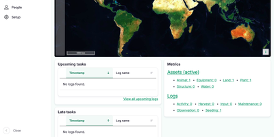
farmOS is the record book, map, and planning board for a working farm, replacing the notebook, the spreadsheet, and the whiteboard with one web app the whole crew can check from the field. The dashboard opens on a map of your land, so you click a field, a barn, or a pasture to reach every record tied to that place. Assets are the things you manage, from fields and animals to equipment and plantings, and Logs are everything that happens to them: seedings, harvests, treatments, movements, and observations, each with dates, notes, and photos. Quantities attach real numbers to those logs, such as kilograms harvested, litres applied, or hours worked, turning daily notes into yields and input costs you can compare across seasons. Quick forms make common entries fast on a phone, and upcoming or late tasks on the dashboard keep pending work from being forgotten. Plans group assets and logs around a purpose such as a grazing rotation or a season of crop production, while reports summarize the records for analysis. Crew members get their own accounts with permissions, records stay private by default, and an API plus add-on modules connect sensors and other farm tools. Running on a dedicated VPS on RepoCloud with guaranteed CPU, RAM, and SSD, full root SSH access, and a browser serial console. GPL-2.0 licensed.
TRIP
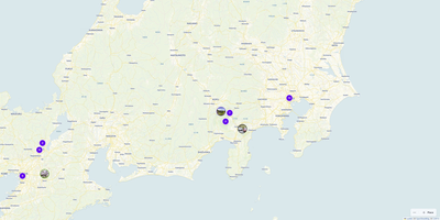
Plan multi-day expeditions, map custom waypoints, and coordinate shared group travel itineraries with TRIP, a private self-hosted journey management platform free from commercial tracking. Travelers can drop custom pins across global topographic or satellite maps, tagging locations with categories, visit durations, cost estimates, accessibility notes, and pet-friendly attributes. The visual trip builder organizes individual stops into ordered daily schedules, helping you calculate travel intervals and rearrange destination sequences using intuitive drag-and-drop tools. You can attach reference photos, booking confirmations, external links, and packing checklists directly to each itinerary milestone. Shared workspace controls enable travel companions to collaborate on upcoming road trips, leave comments on specific attractions, and coordinate shared responsibilities in real time. Dynamic filtering lets you isolate culinary destinations, outdoor hikes, or cultural landmarks by budget and travel style. Offline caching ensures your navigational routes and saved coordinates remain accessible in remote backcountry areas with spotty cellular coverage. Running on a dedicated VPS on RepoCloud with guaranteed CPU, RAM, and SSD, full root SSH access, and a browser serial console. MIT licensed.